Easy GIS .NET Desktop
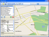 Easy GIS .NET Desktop Edition is a .NET Shapefile library and GIS mapping application.
The software is free and you can include the Easy GIS .NET controls in your own
commercial .NET desktop applications.
Easy GIS .NET Desktop Edition is a .NET Shapefile library and GIS mapping application.
The software is free and you can include the Easy GIS .NET controls in your own
commercial .NET desktop applications.
Download (6.4MB)
Features
- Includes .NET Shapefile Control and .NET Shapefile reader
- Supports Point, PointZ, PolyLine, PolyLineZ, PolyLineM, Polygon, PolygonZ, MultiPoint and MultiPointZ
- Projection support
- Low memory footprint
- Extremely fast rendering speed
- Designed for opening and rendering very large shapefiles
- Edit or create shapefiles from .NET applications
Easy GIS .NET Web
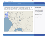 Easy GIS .NET Web is a collection of ASP .NET Mapping Web Controls for developers
to add GIS map functionality to web sites,
utilizing the same rendering components as the desktop version of Easy GIS .NET.
Easy GIS .NET Web is a collection of ASP .NET Mapping Web Controls for developers
to add GIS map functionality to web sites,
utilizing the same rendering components as the desktop version of Easy GIS .NET.
Download (6.4MB)
Features
- Extremely fast rendering speed
- Custom rendering support
- ASP .NET Tiled Map Control
- Load ShapeFiles in Google Maps
- GeoJSON and Mapbox Vector Tile support.